-
Title
-
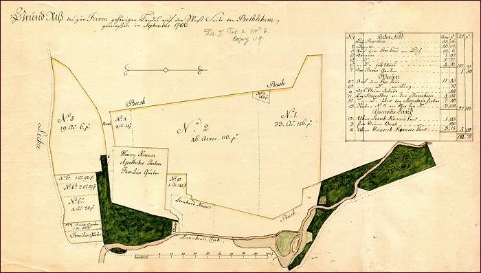
Plan of the farmlands on the west side of Bethlehem, north of the Lehigh, west of the Monocacy
-
Alternative Title
-
"Grund Riss des zur Farm gehoerigen Landes auf der West Seite von Bethlehem"
-
Creator
-
Golkowsky, Georg Wenzeslaus, 1725-1813, surveyor
-
Publisher
-
Bethlehem Digital History Project
-
Date
-
1786-09
-
Type
-
Still image
-
Format
-
image/jpg, 11 1/2" x 18 1/2" (295 mm x 465 mm)
-
Description
-
Plan of the farmlands on the west side of Bethlehem, north of the Lehigh, west of the Monocacy as drawn by Georg Wenzeslaus Golkowsky in 1786. Ink and watercolor on paper. Scale: 1 inch to twenty perches.
-
Subject
-
Bethlehem (Pa.)
Maps
Drawings
-
Identifier
-
f.023.3
-
Language
-
German
-
Extent
-
1 sheet
-
Rights Holder
-
Moravian Archives, Bethlehem, Pennsylvania